
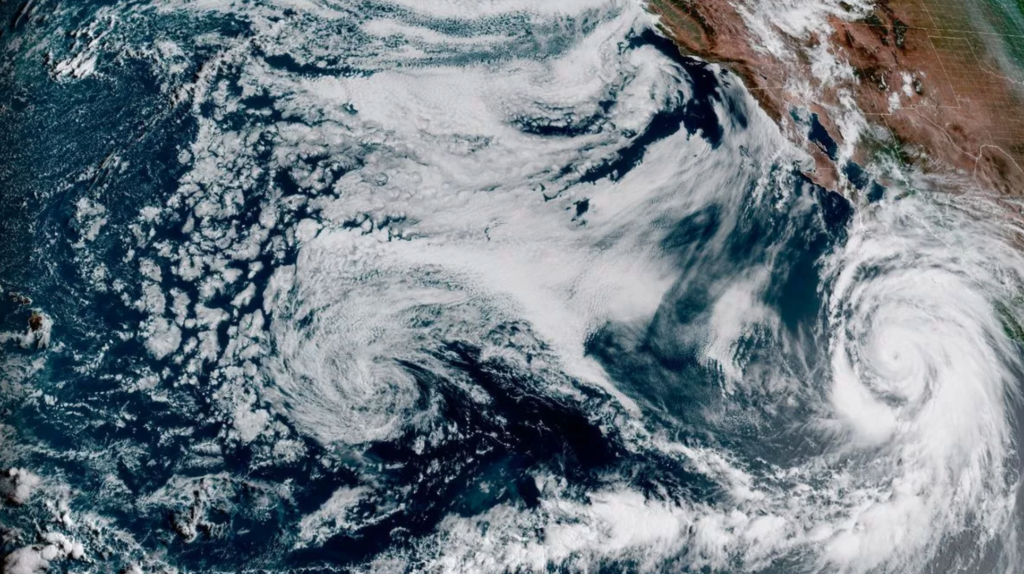

As Hurricane Hilary approaches, some parts of Southern California and southern Nevada may receive a year’s worth of rain in a matter of days. Historic flooding is projected to affect a wide region of Southern California and the Las Vegas area, particularly in San Bernardino and Inyo counties, with Death Valley and the Morongo Basin expected to be the hardest hit.
Hurricane Hilary: Officials have warned of impending flooding
By the time Hilary departs Mexico and hits California, it will most certainly have degraded into a tropical storm. However, officials are warning of impending flooding. “Everyone should brace themselves for the possibility of significant flash flooding.” This is not the time to put off planning; the outlook is unlikely to improve,” according to the National Weather Service in Las Vegas, which also publishes forecasts for other cities.
Some areas could even see as much as a year’s worth of rain in a 24-hour period Sunday — and if not then, over the next few days. “This will not be a constant rainfall, but rather several rounds of moderate/heavy rainfall,” from Friday through Monday, the weather service said. “Once impacts begin in your areas, they will likely worsen as we head into next week,” forecasters said. Sometimes the rain “could be slowly compounding. Other times, it could be flash flooding. There is not much time between rounds of rain for conditions to improve.”
Rainfall totals of 6 to 10 inches are likely along the east-facing desert slopes of Riverside, San Bernardino, and San Diego County
The National Weather Service predicts that other desert areas will receive at least a year’s worth of rain during the storm. Both Palm Springs and Yucca Valley receive 4 to 5 inches of rain each year on average, but a deluge of 4 to 7 inches is expected between Saturday and Monday, according to Elizabeth Adams, a meteorologist with the San Diego weather service. “The amount of moisture we’re getting is just unbelievable,” Adams said. “The rain rates could potentially be really extreme as well—over an inch or 2 inches of rain in an hour will be possible.”
Rainfall totals of 6 to 10 inches are likely along the east-facing desert slopes of the Riverside, San Bernardino, and San Diego County mountains, according to Adams. She recommended citizens in the storm’s path keep an eye on forecast updates and have various ways to receive warnings, such as wireless emergency alerts, weather apps, and local TV, radio, and news stations. Officials in Yucca Valley are asking people to be cautious and avoid needless driving, as access to some local roads may be limited.
“As the ability to travel may be reduced over the next two days, residents are reminded to keep a supply of necessary provisions and medications on hand,” Yucca Valley officials said on X, formerly known as Twitter. “Be sure to bring pets inside. Never use generators, outdoor heating, or cooking equipment indoors.” The National Weather Service office in Phoenix, which issues forecasts for portions of southeastern California, said it’s likely the storm will have “significant and rare (and potentially destructive) impacts.”
Every drop of rain predicted for Hurricane Hilary is unusual, and it poses a “life-threatening” risk of flash floods
Current models show moisture anomalies that are “off the charts,” the agency wrote in its latest forecast, “and almost unbelievably more extreme than previous iterations. Essentially, every drop of rain predicted for Hurricane Hilary is unusual, and it poses a “life-threatening” risk of flash floods. The field measure is pegged at a climatological extreme for this time of year at multiple time scales.”
The rains predicted for Hurricane Hilary are unusual, and they pose a “life-threatening” risk of flash floods from Baja California to southern Nevada. A tropical storm watch is in force across much of southern California, from the California-Mexico border into sections of Los Angeles County, a first for this area, according to the National Hurricane Center. According to the hurricane center, a watch means that tropical storm conditions—defined as sustained winds of greater than 39 mph—are possible within 48 hours.
While high winds are creating unusual tropical storm conditions, officials continue to emphasize that rain remains the greatest concern. “This could [bring] rare and life-threatening flash flooding in the heaviest areas of rainfall. That is especially going to be prevalent Sunday evening through Monday morning,” said Elizabeth Adams, a meteorologist with the National Weather Service in San Diego.’A high-risk rain warning has been issued for much of inland Southern California, ranging from the San Bernardino Mountains through the Coachella Valley and down into the Anza Borrego Desert, signifying a high likelihood of flash floods on Sunday and Monday. According to Adams, the warning was issued for the first time in more than a decade for the low deserts east of the Southern California mountains, which are generally the drier-facing slopes.
Rainfall in the Southland’s mountains and deserts is forecast to begin as early as Saturday morning and continue through Monday, with eastern-facing mountains likely to get the most extreme amounts of rain, ranging from 6 to 10 inches, and up to a foot in some isolated regions. Rainfall of three to six inches is forecast across the deserts. Precipitation will likely spread into the beaches and valleys, including the Inland Empire, by late Saturday, with 2 to 4 inches forecast through Monday. The National Weather Service predicts that Big Bear Lake, Julian, Idyllwild, and Mt. Laguna will receive up to 7 inches of rain between Saturday and Monday. Up to 5 inches of rain might fall in the Coachella Valley, including Palm Springs. Hemet, San Bernardino, and Hesperia are all nearby cities.