


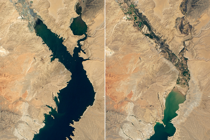
NASA on Wednesday shared stark pictures showing Lake Mead, the largest US reservoir is 73 percent empty. Here’s more on the situation.
Lake Mead is on the path of decline

NASA’s new images show the depth of damage caused by the continuing megadrought. The U.S. Bureau of Reclamation said water stages are near levels last seen in April 1937, and it’s estimated the reservoir is at 27 percent of capacity.
Newly released satellite images by NASA’s Earth Observatory reveal a surprising decline in water levels. The water from the reservoir is used by millions of people from farmers to communities living on tribal lands across Nevada, Arizona, northern Mexico, and California.
Additionally, it is also a vital source of irrigation and drinking water in the Southwest. Moreover, Lake Mead is a popular boating destination and national recreation area.
Michael Carlowicz, of NASA’s Earth Observatory, called the shocking state of Mead a “stark illustration of climate change and a long-term drought that may be the worst in the US West in 12 centuries.”
More on the drastic shrink
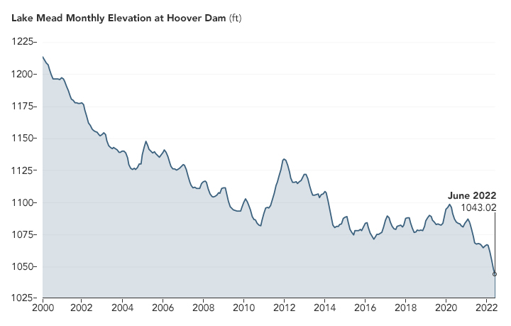
This is the result of a 22 years long downward trend. The reservoir’s water levels are the lowest they’ve been since April 1937, a time when the reservoir which has a maximum storage capacity of 9.3 trillion gallons was still being filled for the first time.
Currently, as per the US National Park Service, five of the six boat launches in the region are closed. Their website states that the “Declining water levels due to climate change and 20 years of ongoing drought have reshaped the park’s shorelines.” “As Lake Mead continues to recede, extending launch ramps becomes more difficult and more expensive due to the topography and projected decline in water levels,” it added.