


A tropical cyclone is strengthening in the Bay of Bengal and is on its way to impact western Myanmar and Bangladesh’s Cox’s Bazar, where over 1 million Rohingya refugees live in flimsy shelters in what many see as the world’s largest refugee camp.
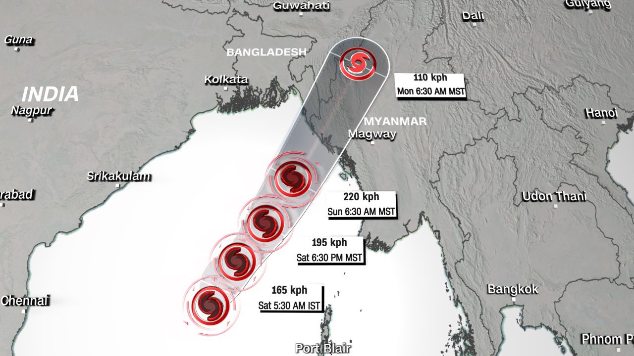
Cyclone Mocha is the first to emerge in the Bay this year, and it is forecasted to strengthen further before reaching landfall on Sunday, most likely in western Myanmar’s Rakhine state, near the Bangladesh border.
Mocha developed Friday into the equivalent of a category 1 Atlantic hurricane, according to the Joint Typhoon Warning Center, and is moving north at 11 kilometers per hour (7 miles per hour).
Cyclone Mocha: Potential Impact on Rohingya Refugees and Emergency Preparations
Winds from the storm might reach 220 kph (137 mph), which is equivalent to a category 4 Atlantic hurricane – just before making landfall on Sunday morning, the agency said.
Mocha, according to India’s Meteorological Department, has strengthened into a very severe cyclonic storm and has cautioned fishermen and trawlers not to sail too deep into the Bay in the coming days.
At the time of landfall, a storm surge of up to 2.5 meters (8.2 feet) was expected to inundate low-lying coastal regions in the path of the cyclone.
This includes Cox’s Bazar in Bangladesh, which is home to members of the stateless Rohingya group who fled persecution in neighboring Myanmar during a military campaign in 2017. Many people live in bamboo and tarpaulin shelters situated on hilly hillsides prone to severe winds, rain, and landslides.
Concerns have also been raised about hundreds of Rohingya refugees housed in Bhasan Char, a remote and flood-prone island facility in the Bay of Bengal.
Aid organizations are increasing their emergency planning and reaction with local and refugee communities ahead of Mocha’s probable landfall.
In a tweet, the UNHCR claimed that “emergency preparations in the camps and on Bhasan Char are underway” in collaboration with the government and local humanitarian organizations.
“In preparation of cyclones, hundreds of Rohingya refugee volunteers have been trained on identifying risks, informing their communities, evacuating people when needed, and responding after disaster strikes,” the UNHCR said in a tweet.
Past Cyclone Impacts and preparedness efforts in Myanmar
According to local independent media Myanmar Now, inhabitants in coastal portions of Rakhine state and Ayeyarwady region have begun to abandon their homes and seek shelter ahead of the cyclone’s projected landfall.
According to state media Global New Light of Myanmar, the ruling Myanmar junta has issued cyclone warnings and claims to be taking preventative steps such as preparing disaster management committees to respond to a potential calamity.
The Joint Typhoon Warning Center predicts severe flooding, landslides, and high wind gusts in the vicinity of landfall and across Myanmar’s interior.
Maarutha, the most recent designated tropical storm to make landfall in Myanmar, made landfall in April 2017. Despite being the equivalent of a tropical storm when it made landfall, with maximum speeds of 92 kph (58 mph), Maarutha produced significant rains and destroyed almost 100 dwellings.
The last storm to make landfall with hurricane-force winds was Tropical Cyclone Giri in October 2010. It made landfall as a Category 4 comparable storm with maximum winds of 250 kilometers per hour (155 miles per hour).
Giri killed about 150 people and damaged roughly 70% of the city of Kyaukphyu in Rakhine state. According to the United Nations, around 15,000 dwellings were destroyed during the storm.
“The worst natural disaster to hit Myanmar was Cyclone Nargis in May 2008, killing 140,000 people, severely affecting 2.4 million, and leaving 800,000 displaced,” aid agencies said.